About CLIWAT
CLIWAT- Adaptive and sustainable water management and protection of society and nature in an extreme climate
The CLIWAT project will apply groundwater and integrated hydrological models for assessment of the hydrological impacts of different climate scenarios with focus on water table fluctuations, river discharge, delineation of flood risk areas and saltwater intrusion. The hydrological scenario simulations will be based on output from existing climate models and geological and geophysical measurements and modelling of the subsurface partly conducted in the project.
The results from the project will be used to predict how future climate change will affect water quantity and quality, and hence societies and ecosystems in lowlands around the North Sea. CLIWAT will provide the needed data for development of adaptive measures and new standards for e.g. engineering of drainage and sewer systems, dikes, roads and buildings, and for quantitative and chemical status assessments of groundwater and the aquatic environment according to EU directives.
The CLIWAT project will initiate important transboundary cooperation and evaluation of the effect of different climate scenarios in the EU North Sea region and establish predictive modelling tools for future simulations. The project website is intended to provide easy access to simulation results in the form of maps and visualisations facilitating cooperation and with the aim of increasing the the public awareness and understanding about climate change effects.
Partners:
- Region Midtjylland (coordinator, Public regional authority - Denmark)
- LIAG (Public cooperation -Germany)
- Geological Survey of Denmark and Greenland / GEUS (Governmental research organisation - Denmark)
- Region Syddanmark (Public regional authority - Denmark)
- LLUR (National authority - Germany)
- Geological Survey of the Netherlands / Deltares (Governmental research organisation - Netherlands)
- Environment Centre Århus (Public regional authority - Denmark)
- Environment Centre Ribe (Public regional authority - Denmark)
- Aarhus University (University - Denmark)
- Ghent University (University - Belgium)
- SEECON (SME - Germany)
- Municipality of Horsens (Public local authority - Denmark)
- BGR (Public national authority - Germany)
- VITENS (SME - Netherlands)
- Provincie Fryslan (Public regional authority - Netherlands)
- Wetterskip Frysland (Public regional authority - Netherlands)
Objectives
- To develop and apply groundwater and integrated hydrological and geological / geophysical models for adaptive and sustainable water management in an extreme climate
- To assess the hydrological impacts of different climate scenarios with focus on water table fluctuations, river discharge, delineation of flood risk areas and saltwater intrusion by use of the developed models
Work packages
WP 1: Project coordination (Lead: Region Midtjylland)
WP 2: Transboundary case studies (Lead: LANU)
WP 3: Boards / end-user dialogue and dissemination (Lead: SEECON)
WP 4: Field work (Lead: LIAG)
WP 5: Geological modelling (Lead: Deltares)
WP 6: Hydrological and climate scenario modelling (Lead: GEUS)
WP 7: Groundwater status assessment and EU directives (Lead: GEUS)
WP 8: Adaptive management of climate change (Lead: Region Midtjylland)
Field sites
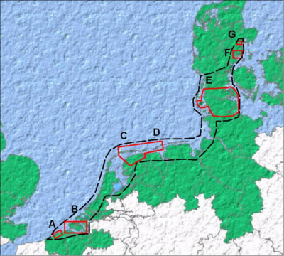
A. Belgische Middenkust (B): Modelling, salinisation
B. Zeeland (B/NL): Modelling, salinisation, eutrophication
C. Terschelling and Northern Frysland (NL): Geomapping
D. Borkum (D): Geomapping, salinisation, modelling
E. Schleswig and S. Jutland (D+DK): Geomapping, modelling, GW tresholds, salinisation, eutrophication
F. Egebjerg (DK): Modelling, groundwater table fluctuations, land use planning
G. Aarhus river (DK): Modelling, point sources
|